
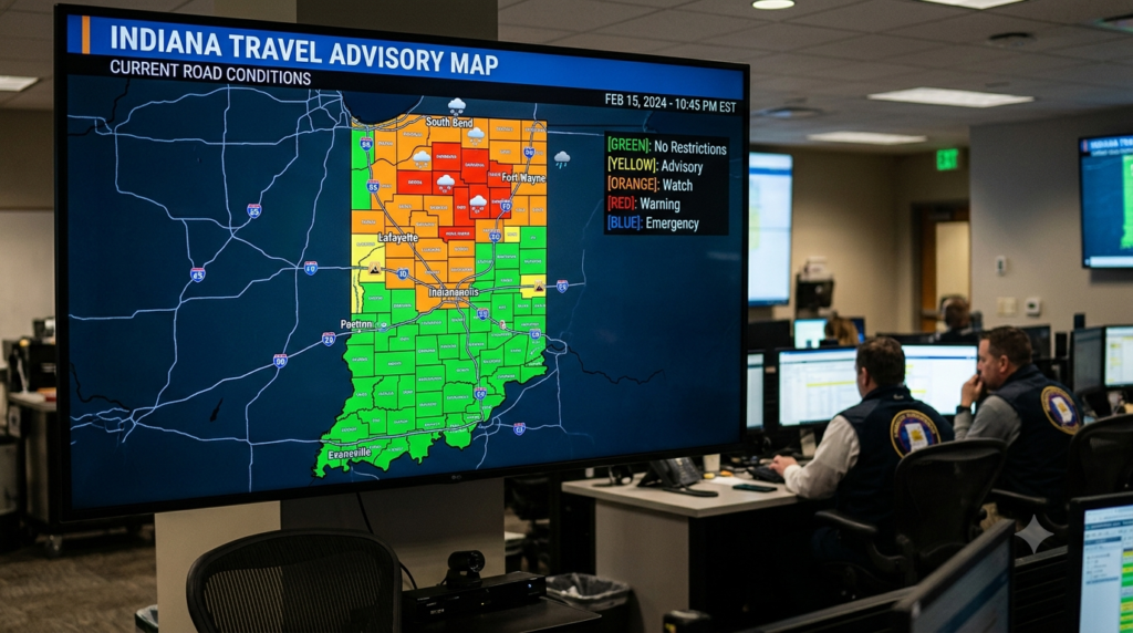

The Indiana travel advisory map is an official online resource that allows residents, commuters, visitors, and travelers to check county level travel statuses across Indiana. The map is maintained through the Indiana Department of Homeland Security’s travel advisory system, with information supplied by individual county emergency management agencies.
Instead of treating the entire state as having one travel condition, the system allows travelers to see conditions at the county level. This is particularly useful during snowstorms, ice events, flooding, severe thunderstorms, tornado related emergencies, or other situations that could affect transportation and public safety. The official system allows users to select a county on the interactive map or choose one from a dropdown list, while a table below the map provides county by county information.
The map is designed to help people make better informed decisions before traveling. A county experiencing hazardous conditions may have a different travel status from a neighboring county, so checking the specific area where you are traveling is important.
It is also important to understand that the travel advisory map is not the same thing as a live traffic map. The county advisory system communicates the level of local travel concern, while road closures, construction, traffic incidents, and pavement conditions may require separate information from the Indiana Department of Transportation and other transportation agencies.
Latest Update on the Indiana Travel Advisory Map
The latest information on the Indiana travel advisory map should always be checked directly through the official state website because county statuses can change as conditions develop. The Indiana Department of Homeland Security explains that travel status information is provided by county emergency management agencies and that the map changes when counties initiate official travel advisories and notify the state.
One important detail for anyone checking the map is that the online display does not automatically refresh inside an open browser window. The state advises users to refresh or reload the page to obtain the most updated version of the map. This is particularly important during fast moving weather events when conditions can change within a short period.
Travelers should therefore avoid relying on an old screenshot shared on social media or a previously viewed map. A county that was under an advisory earlier in the day may have moved to a different status later, while another county could have introduced a new restriction.
For the most reliable information, check the official map shortly before departure and again if weather or emergency conditions are changing. If you are traveling across several counties, check each county along your route rather than looking only at your starting point or destination.
How to Read the Indiana Travel Advisory Map
Using the map is relatively straightforward. The official Indiana system allows users to select a county directly from the interactive map or use a dropdown menu to locate a specific county. The selected county’s travel status and the most recent time that information was provided are displayed for reference. A county by county table is also available below the map.
The update time is an important part of interpreting the information. A status is not simply a permanent label attached to a county. Emergency management agencies may change the status as conditions improve or deteriorate. Looking at when the status was last changed can help you understand how recent the information is.
If you are planning a journey through multiple Indiana counties, make a list of the counties on your route and check them individually. This is especially useful during winter storms or widespread severe weather because road conditions can vary significantly between locations.
The map should also be viewed as one part of a broader travel safety check. A county may have no elevated travel advisory while a particular road is affected by construction, flooding, an accident, or another localized issue. For that reason, checking both county travel status and current transportation information is a better approach than depending on one source alone.
Indiana Travel Advisory Levels Explained
Indiana’s local travel advisory system uses different levels to communicate the severity of hazardous conditions. Understanding these terms is essential because an Advisory is not the same as a Watch, and a Watch is not the same as a Warning.
The official system identifies Advisory as the lowest level of local travel advisory. It means routine travel or activities may be restricted in certain areas because of a hazardous situation, and people should use caution or consider avoiding affected areas. The system also identifies Watch and Warning levels for more serious situations.
Advisory
An Advisory indicates that hazardous conditions may affect normal travel or activities. Routine travel may be restricted in some locations, and travelers are encouraged to use caution or avoid affected areas when appropriate.
For example, an advisory could be issued during weather or other hazardous circumstances where conditions have become concerning but do not reach the more restrictive levels. Travelers should evaluate the situation before leaving and allow extra time if conditions are difficult.
Watch
A Watch means conditions are threatening to public safety. Under this level, only essential travel, such as travel to and from work or travel required for emergencies, is recommended.
The state also advises organizations such as businesses, schools, government agencies, and other groups to implement emergency action plans when a Watch is in effect. Travelers should take the warning seriously and consider whether their journey is genuinely necessary.
Warning
A Warning represents the highest level of local travel advisory. Under this status, travel may be restricted to emergency management workers only.
The official guidance directs individuals to refrain from travel, comply with necessary emergency measures, cooperate with public officials and disaster response personnel, and follow lawful directions from properly identified officers. Indiana law also provides additional exceptions and provisions related to Warning level travel advisories.
No Elevated Status Reported
When a county shows No Elevated Status Reported, it means the county is not currently reporting an elevated travel advisory through the system. However, this should not automatically be interpreted as a guarantee that every road is clear or that no hazards exist.
The travel advisory system depends on county emergency management reporting. Other factors, including weather, road construction, accidents, flooding, and temporary closures, may still affect individual roads and communities.
What Does an Indiana Travel Advisory Mean for Drivers?
An Indiana travel advisory is intended to help people understand the seriousness of conditions affecting travel in a particular county. It does not necessarily mean that every road in the county is closed. Instead, the level communicates the local government’s assessment of conditions and the recommended approach to travel.
The distinction between an advisory and a road closure is important. A county could be under an Advisory while some roads remain open, although conditions may be hazardous. Conversely, a particular highway or local road could be closed because of an incident even if the broader county does not have a high level travel advisory.
Drivers should therefore consider the advisory level alongside current road conditions. During winter weather, for example, snow and ice can affect roads differently depending on location, elevation, traffic, and treatment operations.
If you are driving during hazardous conditions, allow additional time, reduce speed when necessary, maintain a safe following distance, and follow official instructions. If authorities advise against nonessential travel, postponing the journey may be the safest choice.
Why Is the Indiana Travel Advisory Map Important?
The Indiana travel advisory map is especially important because hazardous conditions are often localized. A major snowstorm may affect northern Indiana differently from southern Indiana, while flooding or severe thunderstorms may create isolated hazards in specific counties.
A county level map provides a more detailed picture than a general statement such as “Indiana has bad weather.” Travelers can identify the specific areas where authorities have issued elevated statuses and adjust their plans accordingly.
The map is also useful for people who regularly commute across county boundaries. Someone traveling from one Indiana county to another may encounter very different conditions along the route. Checking only the destination may not provide enough information about the entire journey.
For businesses, schools, public agencies, and organizations, the advisory system can also provide valuable information for operational decisions. A higher level advisory may affect staffing, transportation, deliveries, events, and emergency planning.
How to Check Indiana Road Conditions
The Indiana travel advisory map and road condition information serve different purposes, so travelers should ideally consult both. The Indiana Department of Homeland Security’s travel advisory system provides county level advisory statuses, while the Indiana Department of Transportation provides transportation related information.
The Indiana State Police directs travelers toward the county travel status map for advisory levels and INDOT resources for real time road restrictions, closures, and conditions. The Indiana State Police also identifies the INDOT road conditions phone line at 1 800 261 ROAD (7623).
The Indiana Department of Transportation’s travel information resources also connect travelers with Indiana travel conditions and related transportation information. This can be particularly useful when you need details about road restrictions, construction, traffic, or closures that may not be fully explained by a county level advisory status.
Weather information should also be considered. During severe weather, the latest forecast and warnings can help explain why a county has elevated its travel status. A map showing an Advisory alone may not provide enough context for making a safe decision.
How Travelers Should Use the Map
Before leaving home, check the official Indiana travel advisory map for your county and destination. If your route crosses multiple counties, review each area along the journey. This simple step can help you identify elevated travel statuses before you get on the road.
After checking the county map, look at current road conditions and weather forecasts. This creates a more complete picture of the trip. For example, an Advisory might indicate that caution is necessary, while INDOT information could reveal a specific road closure that requires a detour.
During changing weather, continue monitoring official information. A status can change as county emergency management agencies receive new information and update their advisories.
The most important principle is to avoid treating the map as a one time check. If conditions are deteriorating, information from an hour earlier may no longer represent the situation on the ground. Refresh the official map and review current road and weather information before continuing your trip.
Does the Indiana Travel Advisory Map Cover Every County?
The Indiana travel advisory system is designed around county level reporting. The official map and table allow users to review travel statuses for counties across Indiana rather than relying on a single statewide travel classification.
County emergency management agencies are responsible for providing the travel status information used by the system. As counties initiate official travel advisories and notify the state, the map is updated with the relevant information.
This structure means that local conditions can be communicated more precisely. However, it also means travelers should pay attention to the source and timing of each status.
If a county is not reporting an elevated status, that does not mean every possible travel issue has been ruled out. Localized hazards may not necessarily result in the same countywide advisory level, and transportation agencies may have separate information about specific roads.
Indiana Travel Advisory Map vs. Road Closure Information
One of the most common misunderstandings is assuming that the Indiana travel advisory map is a complete road closure database. It is not. The map is primarily a county level travel status system designed to communicate the severity of local conditions and recommended travel behavior.
Road closure information is more specific. A road may be closed because of flooding, a crash, construction, a bridge problem, debris, or another emergency. Such a closure may affect only a small part of a county.
For this reason, travelers should use the Indiana travel advisory map to understand the broader local situation and then consult transportation resources for specific road conditions.
Combining these sources is particularly important for long distance travel. A traveler driving across Indiana may need to check multiple counties, road restrictions, construction zones, and weather conditions before departure.
Common Mistakes When Checking Travel Advisories
One common mistake is relying on an old screenshot of the travel advisory map. Because county statuses can change, a screenshot shared online may no longer represent current conditions. The official Indiana system advises users to refresh or reload the map because it does not automatically refresh in the browser.
Another mistake is checking only the destination county. If you are traveling through several counties, the conditions along the route may differ considerably. A safer approach is to check every major county along your planned journey.
Travelers should also avoid confusing an Advisory with a complete road closure. The advisory level provides broader guidance about travel conditions, while specific road restrictions may need to be checked through transportation agencies.
Finally, do not ignore the highest levels of the system. A Warning indicates an extremely serious situation in which travel may be restricted to emergency management workers. During such circumstances, following official instructions is more important than attempting to complete a nonessential journey.
Conclusion
The Indiana travel advisory map is an important resource for anyone who needs to understand current county level travel conditions across the state. Its main purpose is to communicate local travel statuses reported by county emergency management agencies, helping residents and visitors make more informed decisions when hazardous conditions affect travel.
Frequently Asked Questions About the Indiana Travel Advisory Map
What is the official Indiana travel advisory map?
The official Indiana travel advisory map is a county level online resource provided through the Indiana Department of Homeland Security. It allows users to check travel statuses reported by county emergency management agencies.
What does an Indiana Advisory travel status mean?
An Advisory is the lowest level of local travel advisory. It indicates that routine travel or activities may be restricted in areas because of hazardous conditions. Travelers should use caution and consider avoiding affected areas when appropriate.
What does a Watch mean on the Indiana travel map?
A Watch means conditions are threatening public safety. Only essential travel, such as travel to work or for emergencies, is recommended, and organizations are advised to implement emergency action plans.
What does a Warning mean on the Indiana travel advisory map?
A Warning is the highest level of local travel advisory. Travel may be restricted to emergency management workers only, and individuals are directed to refrain from travel except where applicable under official rules and exceptions.
Does an Indiana travel advisory mean roads are closed?
Not necessarily. A travel advisory communicates the level of hazardous conditions and recommended travel behavior at the county level. Specific road closures and restrictions should be checked through Indiana transportation resources.
How often does the Indiana travel advisory map update?
The map updates when county emergency management agencies provide new travel status information. However, the official site advises users to refresh or reload the browser to see the most updated version because the map does not automatically refresh.
Where can I check Indiana road conditions?
Travelers can use Indiana Department of Transportation resources for road restrictions, closures, and travel conditions. The Indiana State Police also points travelers toward INDOT resources and provides the INDOT road conditions phone line at 1 800 261 ROAD.
Is the Indiana Travel Advisory app still available?
The Indiana Department of Homeland Security’s current travel advisory map page states that the Travel Advisory App is no longer available. Users can still access the travel advisory map through the website on mobile devices.